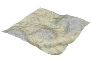
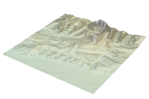
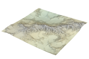
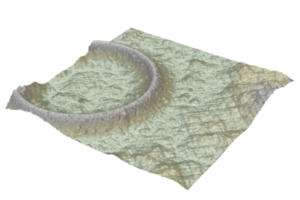
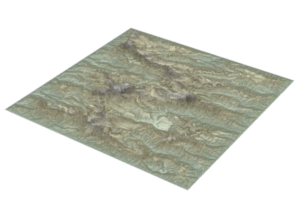
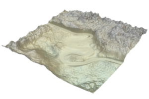
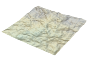
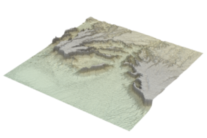
Authoring Landscapes by Combining Ecosystem and Terrain Erosion Simulation
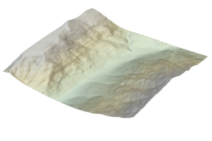
Description
300 steps have been applied of Cordonnier 2017 method
Format
16 bits greyscale Tiff Cell size: 10m/pixel Alt min: 1057.71 Alt max: 2061.54 Latitude (°): 45 Compass (°); 90
Resolution
256x256
Source
Provided by authors
Files
[Cordonnier-2017.tiff] : main DEM
[Cordonnier-2017-0iteration.tiff] : initial terrain before simulation
![[Fournier-1982.png]](DEMs/Fournier-1982.png)
![[Fournier-1982-0.png]](DEMs/Fournier-1982-0.png)
![[Fournier-1982-1.png]](DEMs/Fournier-1982-1.png)
![[Fournier-1982-2.png]](DEMs/Fournier-1982-2.png)
![[Fournier-1982-3.png]](DEMs/Fournier-1982-3.png)
![[Fournier-1982-4.png]](DEMs/Fournier-1982-4.png)
![[Fournier-1982-5.png]](DEMs/Fournier-1982-5.png)
![[Fournier-1982-6.png]](DEMs/Fournier-1982-6.png)
![[Fournier-1982-7.png]](DEMs/Fournier-1982-7.png)
![[Faulting.png]](DEMs/Faulting.png)
![[Faulting-50.png]](DEMs/Faulting-50.png)
![[Faulting-100.png]](DEMs/Faulting-100.png)
![[Faulting-200.png]](DEMs/Faulting-200.png)
![[Hydraulic.png]](DEMs/Hydraulic.png)
![[Hydraulic-original.png]](DEMs/Hydraulic-original.png)
![[Hydraulic-sand.png]](DEMs/Hydraulic-sand.png)
![[Guerin-2017.png]](DEMs/Guerin-2017.png)
![[Guerin-2017-input.png]](DEMs/Guerin-2017-input.png)
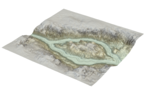
![[Guerin-2017-river.png]](DEMs/Guerin-2017-river.png)
![[Guerin-2017-riverbed.png]](DEMs/Guerin-2017-riverbed.png)
![[Stava-2008.png]](DEMs/Stava-2008.png)
![[Cordonnier-2016.png]](DEMs/Cordonnier-2016.png)
![[Belhadj-2005.png]](DEMs/Belhadj-2005.png)
![[Belhadj-2005-skeleton.png]](DEMs/Belhadj-2005-skeleton.png)
![[Multifractal-noise.png]](DEMs/Multifractal-noise.png)
![[Gain-2015.png]](DEMs/Gain-2015.png)
![[Gain-2015-2.png]](DEMs/Gain-2015-2.png)
![[Gain-2015-3.png]](DEMs/Gain-2015-3.png)
![[Gain-2015-4.png]](DEMs/Gain-2015-4.png)
![[Cordonnier-2018.png]](DEMs/Cordonnier-2018.png)
![[Guerin-2016.png]](DEMs/Guerin-2016.png)
![[Guerin-2016-full.png]](DEMs/Guerin-2016-full.png)
![[Guerin-2016-sketch.png]](DEMs/Guerin-2016-sketch.png)
![[Guerin-2016-rivermap.png]](DEMs/Guerin-2016-rivermap.png)
![[Guerin-2016-riverbedmap.png]](DEMs/Guerin-2016-riverbedmap.png)
![[Guerin-2016-withoutriver.png]](DEMs/Guerin-2016-withoutriver.png)
![[Ridged-noise.png]](DEMs/Ridged-noise.png)
![[Simplex-noise.png]](DEMs/Simplex-noise.png)
![[Genevaux-2015.png]](DEMs/Genevaux-2015.png)
![[Belhadj-2007.png]](DEMs/Belhadj-2007.png)
![[Belhadj-2007-skeleton.png]](DEMs/Belhadj-2007-skeleton.png)
![[Gain-2009.png]](DEMs/Gain-2009.png)
![[Gain-2009-2.png]](DEMs/Gain-2009-2.png)
![[Zhou-2007.png]](DEMs/Zhou-2007.png)
![[Mandelbrot-1982.png]](DEMs/Mandelbrot-1982.png)
![[Thermal.png]](DEMs/Thermal.png)
![[Thermal-original.png]](DEMs/Thermal-original.png)
![[Warped-noise.png]](DEMs/Warped-noise.png)