|
KITE |
|
||||
|
|
|
|
|||
|
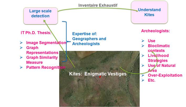
The aim of this research project
is recognizing Kites on satellite images using a graph based approach. Kites
are remnants of long stone walls that outline the shape of a child’s kite.
But the kites are huge, their big size makes them often clearly visible on
high-resolution satellite images. A large scale recognition of kites on their
wide distribution area, will help archeologists of various fields to
understand these enigmatic constructions. The Kite project makes progress on
the basis of cooperation with the ANR project Global Kite. An important aspect of the project is the
development of a pattern recognition tool that will automatically find kites
on satellite images. This tool will allow a comprehensive inventory of these
structures worldwide. From this inventory, a study is conducted, from the
Arabian peninsula to the Caucasus, on the relationship between habitat areas
and areas of kites combined with an identification of all the zooarchaeological data available in the literature to
analyze the issue of kites on the economies subsistence and the importance of
hunting and farming in the early urban societies. The systematic identification of kites on satellite
images enables to delimit spatially this phenomenon. It also identifies other
hunting or pastoral developments that are analogous to kites but must be culturally
excluded. Large scale kite identification can only be
carried out by a gradual work in close collaboration with archaeologists,
geographers and computer scientists. A first model for kite recognition will
be established based on the archaeological and geographical knowledge. This
model will be enriched progressively with the feedback of archaeologists and
geographers experts on the results provided by the model. Object recognition
in images is an area of intensive research
worldwide, and especially in recent years. This research has many locks, some
of which may be considered in this project, such as technical fast graph matching,
modeling images by graphs and especially taking into account the information
of color, shape and texture in the graph models used for kite recognition in
satellite images.
|
|||||