Page Tools
- Member of the IMU Labex
Study, evaluate and model urban sprawl phenomenon using open data
- Collaboration with Luciano Gervasoni, Peter Sturm, Martí Bosch and Samba Diop
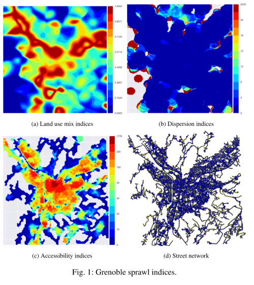
Urban sprawl has been related to numerous negative environmental and socioeconomic impacts. Meanwhile, urban areas have been growing at alarming rates, urging for assessing sprawl towards sustainable development. However, sprawl is an elusive term and different approaches to measure it have lead to heterogeneous results. Moreover, most studies rely on private/commercial data-sets and their software is rarely made public, impeding research reproducibility and comparability. Furthermore, many works give as result a unique value for a region of analysis, dismissing local spatial diversity that is vital for urban planners and policy makers.
We present in this work an open source framework for assessing urban sprawl using open data. Locations of residential and activity units are used to measure mixed use development and built-up dispersion, whereas the street network is used to measure accessibility between different land uses. Sprawl patterns are identified, and the resulting spatial information allows focusing on particular neighborhoods for a fine-grained analysis, as well as visualizing each sprawl dimension separately.
Modeling, learning and optimisation for urban smart mobility and trafic forecasting
- Collaboration with Julien Salotti, Christine Solnon, Nour-Eddin El Faouzi and Romain Billot

Urban transport, while being essential for citizens to perform their daily activities, also constitutes one of the major sources of urban pollution (global emissions, local air quality, noise) and physical accidents (the two thirds of them taking place in cities), directly affecting humans health. Moreover, the economic impact of traffic jams on goods transportation within cities reduces the efficiency of urban delivery process and impair its’ economical aspect. In spite of great efforts made to favor modal report from car to other public transportation systems, the quest for an environmentally sustainable urban transport is a common and urgent challenge for all major cities in Europe. In these circumstances, and in order to (i) tackle the challenge of sustainable urban mobility, (ii) efficiently implement decision support tools, and (iii) exploit data allowing the assessment of policies and their resulting effects, urban planners need models. Along the years, different types of urban models have been developed, ranging from the static and aggregate land use-transportation interaction (LUTI) models , to more recent bottom-up, activity and agent-based simulation.
In the context of the Astral IMU Labex project, this work focuses on building a traffic prediction model of road traffic within the city of Lyon by using the Grand Lyon historical measures from more than 650 sensors between the year 2007 and now. This work explore different strategie for building a predictive model, ranging from traditional learning methods to more specific approaches focusing on causality analysis. A main conclusion we wish to convey is that, as almost every question supporting this research is an open one, there can be no universal model to predict efficiently intra-city road trafic.
 Except where otherwise noted, content on this wiki is licensed under the following license: CC Attribution-Noncommercial-Share Alike 3.0 Unported