-
Extreme continuous level of detail for skeleton-based implicit surfaces
May 23, 2026
Our work on level of detail for skeleton-based implicit surfaces has been accepted at Shape Modeling International.
Skeleton-based implicit surfaces, and convolution surfaces in particular, offer an intuitive and expressive representation for geometric modeling. However, their evaluation and rendering remain computationally demanding, and are often affected by aliasing artifacts. In this paper, we introduce a continuous level of detail framework for the automatic simplification of convolution surfaces, achieving up to an order-ofmagnitude reduction in rendering time while mitigating aliasing artifacts. Our solution dynamically adapts the blending behavior between shape components to preserve the perceived visual appearance of the surface, while progressively simplifying the underlying skeletal geometry. In contrast to traditional simplification techniques, our method allows controlled changes in topological genus when visually beneficial. Our results demonstrate that the proposed framework effectively reduces visual artifacts and computational cost, while maintaining high fidelity to the overall shape..
-
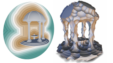
The PhaseTree: Multiphase Signed Distance Fields
May 18, 2026
Our work on multiphase implicit surfaces has been accepted at SIGGRAPH.
We introduce the PhaseTree, a novel hierarchical construction-tree representation for compactly modeling volumetric objects composed of multiple phases or materials across scales. An object is defined as a single construction tree that combines phase-aware primitives through composition and warping operators, yielding a unified multiphase signed distance representation that naturally supports complex topologies and interfaces between phases. The PhaseTree is compatible with standard signed distance field workflows: single-phase algorithms can be directly promoted to a PhaseTree, and conversely reduced without loss of information. As a result, our model integrates seamlessly with existing algorithms and rendering pipelines. We extend classical Sphere Tracing to robustly handle multiphase configurations and show that, despite the additional expressiveness, our implementation preserves the compactness and resolution independence of signed distance fields and incurs less than a 25% runtime overhead compared to single-phase Sphere Tracing.
-
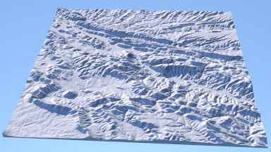
Terrain Synthesis and Authoring based on Iso-Contours
February 6, 2026
Our work on terrain authoring based on iso-contours has been accepted at Computer Graphics Forum.
Digital terrains are central to realistic landscape depiction, yet authoring tools must balance perceptual realism with intuitive artistic control. We propose a compact vector-based representation that models terrain as nested iso-contours, inspired by geomorphology and cartography. Our method departs from traditional grid-based elevation models by generating contours through an inward Open Eden Growth simulation, followed by marching-triangles reconstruction into a Triangulated Irregular Network. This contour framework supports direct editing such as warping, slope modulation, and smoothing, while allowing reconstruction of a standard elevation map for downstream processing, including erosion and amplification. The approach enables the creation of diverse, realistic terrains from minimal user input and offers simple yet powerful control for designers.
-
Authoring Terrestrial Planets with Diffusion Models
February 6, 2026
Our work on diffusion models for planet generation has been accepted at Computer Graphics Forum.
To support the design and subsequent generation of terrestrial planets for use in the creative media, we propose a solution that employs a generative model trained on satellite data from planetary bodies with a defined solid surface, such as the Earth and Mars. A user sketches coarse elevation, landcover, temperature, and precipitation directly onto a globe. Our model then infers high-resolution heightmap and surface appearance layers at planetary scales, with sufficient detail to enable animated flyovers within the exosphere at a distance of a few thousand kilometers from the planet surface. We address the issue of distortion in the mapping from atlas to globe using a quadsphere representation, and the consistency of large-scale geomorphological features by extracting a global river network from the sketch inputs and providing this as conditioning to the diffusion. As our results demonstrate, our generative model provides a balance between: authoring control through a multi-layer painting interface with a satellite image pre-visualization; computation times proportional to the surface area being generated; landscape diversity, displaying, without repetition artefacts, the full range of elevation and landcover features drawn from multiple source planets, and geomorphological plausibility through the provision of a consistent uninterrupted exorheic global river network, where the input sketches allow.
-
Accelerating Signed Distance Functions
June 6, 2025
Our work on signed distance fields has been accepted at Computer Graphics Forum.
Processing and particularly visualizing implicit surfaces remains computationally intensive when dealing with complex objects built from construction trees. We introduce optimization nodes to reduce the computational cost of the field function evaluation for hierarchical construction trees, while preserving the Lipschitz or conservative properties of the function. Our goal is to propose acceleration nodes directly embedded in the construction tree, and avoid external, accompanying data-structures such as octrees. We present proxy and continuous level of detail nodes to reduce the overall evaluation cost, along with a normal warping technique that enhances surface details with negligible computational overhead. Our approach is compatible with existing algorithms that aim at reducing the number of function calls. We validate our methods by computing timings as well as the average cost for traversing the tree and evaluating the signed distance field at a given point in space. Our method speeds-up signed distance field evaluation by up to three orders or magnitude, and applies both to ray-surface intersection computation in Sphere Tracing applications, and to polygonization algorithms.
-
Code Release
July 23, 2025
We recently released the code for several papers.
We have just released the code for several previously published articles, including:
DeadWood: including disturbance and decay in the depiction of digital nature. (2024).
Terrain Amplification using Multi-Scale Erosion. (2024). -
Vector-based Terrain Modelling
June 6, 2025
 Our work on vector based
terrain modeling has been accepted at Computer Graphics Forum.
Our work on vector based
terrain modeling has been accepted at Computer Graphics Forum.
Vector-based graphics offer numerous advantages over grid-based models, including resolution independence and ease of manipulation. Despite these benefits, their use in landscape modeling remains uncommon because of a lack of direct editing and interactive feedback, essential for matching the artist's vision. We introduce a new vector-based model for creating digital terrains based on computationally efficient primitives. We propose a method to convert grid-based digital elevation maps to this representation with a user-defined level of accuracy. Once vectorized, the terrain can be authored using interactive high-level skeleton-based tools adapted to the primitive representation, allowing local deformations that automatically adapt to underlying geomorphological structures and landforms of the terrain.
-
Sphere Carving
May 21, 2025
 Our work on implicit carving
has been accepted at SIGGRAPH.
Our work on implicit carving
has been accepted at SIGGRAPH.
We introduce Sphere Carving, a novel method for automatically computing bounding volumes that closely bound a procedurally defined implicit surface. Starting from an initial bounding volume located far from the object, we iteratively approach the surface by leveraging the signed distance function information. Field function queries define a set of empty spheres, from which we extract intersection points that are used to compute a bounding volume. Our method is agnostic of the function representation and only requires a conservative signed distance field as input. This encompasses a large set of procedurally defined implicit surface models such as exact or Lipschitz functions, BlobTrees, or even neural representations. Sphere Carving is conceptually simple, independent of the function representation, requires a small number of function queries to create bounding volumes, and accelerates queries in Sphere Tracing and polygonization.
-
Terrain descriptors for landscape synthesis, analysis and simulation
April 16, 2025
 Our work on terrain metrics
has been accepted at Eurographics.
Our work on terrain metrics
has been accepted at Eurographics.
Algorithms for terrain synthesis and ecosystem simulations often rely on simple descriptors such as slope, light accessibility, and drainage area. Typically, the results are assessed from a perceptual standpoint, focusing primarily on visual plausibility. Other fields, such as Geomorphology and Earth Sciences, have already proposed several analytical descriptors to measure various terrain properties. This work aims to bridge the gap between these disciplines and Computer Graphics. We provide a comprehensive review of commonly used terrain metrics that may be relevant for landscape synthesis, analysis, or simulations. Additionally, we compare the approaches used in Computer Graphics to see if these metrics, or similar ones, have already been introduced. Moreover, we report feedback from a preliminary study conducted with a group of artists to evaluate the potential applications of previously unused metrics. By implementing all these metrics, we enable performance comparisons (image courtesy of Benoît Martinez, UBISOFT).