-
Multi-scale erosion
April 26, 2024
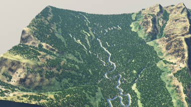
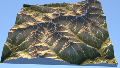 Our work on multi-scale
erosion
has been accepted at SIGGRAPH / ACM Transaction on Graphics.
Our work on multi-scale
erosion
has been accepted at SIGGRAPH / ACM Transaction on Graphics.
Modeling high-resolution terrains is a perennial challenge in the creation of virtual worlds. In this paper, we focus on the amplification of a low-resolution input terrain into a high-resolution, hydrologically consistent terrain featuring complex patterns by a multi-scale approach. Our framework combines the best of both worlds, relying on physics-inspired erosion models producing consistent erosion landmarks and introducing control at different scales, thus bridging the gap between physics-based erosion simulations and multi-scale procedural modeling. The method relies on a fast and accurate approximation of different simulations, including thermal, stream power erosion and deposition performed at different scales to obtain a range of effects. Our approach provides landscape designers with tools for amplifying mountain ranges and valleys with consistent details.
-
Geologically-driven simulation of karst networks
January 30, 2024
Our work on karst simulation has been accepted in the Journal of Hydrology.
In karst aquifers, groundwater flow is highly influenced by the interconnected underground cavities and conduits that form the karst network. Modeling karst flows requires the use of spatially distributed approaches accounting for these networks. Their exploration is, however, often complex, and mapping them using indirect methods such as geophysical ones has proven challenging. To overcome these limitations, stochastically simulating discrete karst networks should account for the uncertainties on conduit position and geometry. Only a few existing methods can reproduce realistic and diverse karst morphologies. In this work, we propose a new algorithm for simulating discrete karst networks, that incorporates field data to generate a range of possible karst network geometries. It relies on the computation of the shortest path between the inlets and outlets of the network with the use of an anisotropic cost function defined on an n-nearest neighbor graph conformal to geological and structural heterogeneities. This cost function represents the physicochemical processes that govern speleogenesis - such as erosion and chemical weathering - providing simplified control over the geometry of the generated networks. Our approach reproduces the vadose-phreatic partition visible in the karst networks, by generating sub-vertical conduits in the unsaturated zone and sub-horizontal ones in the saturated part. It encompasses geological parameters such as inception surfaces, fractures, permeability, and solubility of layers, along with considering the hydrological context of recharge by assigning relative weights to the inlets. We simulate various synthetic models to demonstrate the influence of different input parameters on the spatial organization of the past and present karst flows. The geometrical and topological metrics computed on the simulated networks generally overlap with those of real ones, suggesting the reliability of the method. -
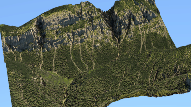
Controlled Procedural Patterns
January 14, 2024
New patterns for enhancing terrains with details have been accepted at Computer Graphics Forum.
Assisting the authoring of virtual terrains is a perennial challenge in the creation of convincing synthetic landscapes. Particularly, there is a need for augmenting artist-controlled low-resolution models with consistent relief details. We present a structured noise that procedurally enhances terrains in real time by adding spatially varying erosion patterns. The patterns can be cascaded, i.e. narrow ones are nested into large ones. Our model builds upon the Phasor noise, which we adapt to the specific characteristics of terrains (water flow, slope orientation). Relief details correspond to the underlying terrain characteristics and align with the slope to preserve the coherence of generated landforms. Moreover, our model allows for artist control, providing a palette of control maps, and can be efficiently implemented in graphics hardware, thus allowing for real-time synthesis and rendering, therefore permitting effective and intuitive authoring.
-
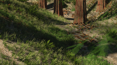
Deadwood
January 4, 2024
 Death and decay
for ecosystem simulation has been accepted at ACM Transaction on Graphics.
Death and decay
for ecosystem simulation has been accepted at ACM Transaction on Graphics.
The creation of truly believable simulated natural environments remains an unsolved problem, partially due to a lack of visual variety. In nature, apart from variation due to abiotic and biotic growth factors, a significant role is played by disturbance events, such as fires, windstorms, disease, and death and decay processes, which give rise to both standing dead trees (snags) and downed woody debris (logs). For instance, snags constitute on average 10% of unmanaged forests by basal area, and logs account for more than twice this quantity. While previous systems have incorporated individual elements of disturbance (e.g., forest fires) and decay (e.g., the formation of humus), there has been no unifying treatment, perhaps because of the challenge of matching simulation results with generated geometric models. In this paper, we present a framework that combines an ecosystem simulation, which explicitly incorporates disturbance events and decay processes, with a model realization process, which balances the uniqueness arising from life history with the need for instancing due to memory constraints. The presence of dead wood in various forms, as snags or logs, significantly improves the believability of natural scenes.
-
EOLE
September 18, 2023
The project EOLE has been accepted by the French ANR. This project aims at modeling and simulating dunes.
-
Authoring Terrains with Spatialised Style
September 8, 2023
 Our work on style
models for terrain generation has been accepted at Pacific Graphics.
Our work on style
models for terrain generation has been accepted at Pacific Graphics.
Various terrain modeling methods have been proposed for the past few decades, providing efficient and often interactive authoring tools. However, they seldom include any notion of style, which is a critical aspect for designers in the entertainment industry. We introduce a new generative network method that bridges the gap between automatic terrain synthesis and authoring, providing a versatile set of authoring tools allowing spatialized style. Given an input sketch or existing elevation map, our method generates a terrain with features that can be authored, enhanced, and augmented using interactive brushes and style manipulation tools. The strength of our approach resides in the versatility and interoperability of the toolbox.
-
Interactive Authoring of Terrain using Diffusion Models
September 8, 2023
 Our work on diffusion
models for terrain generation has been accepted at Pacific Graphics.
Our work on diffusion
models for terrain generation has been accepted at Pacific Graphics.
Honorable Mention from Best Paper Committee.
Generating heightfield terrains is a necessary precursor to the depiction of computer-generated natural scenes in a variety of applications. Authoring such terrains is made challenging by the need for interactive feedback, effective user control, and perceptually realistic output encompassing a range of landforms. We address these challenges by developing a terrain-authoring framework underpinned by an adaptation of diffusion models for conditional image synthesis, trained on real-world elevation data. This framework supports automated cleaning of the training set; authoring control through style selection and feature sketches; the ability to import and freely edit pre-existing terrains, and resolution amplification up to the limits of the source data. Our framework improves on previous machine-learning approaches by: expanding landform variety beyond mountainous terrain to encompass cliffs, canyons, and plains; providing a better balance between terseness and specificity in user control, and improving the fidelity of global terrain structure and perceptual realism. This is demonstrated through drainage simulations and a user study testing the perceived realism for different classes of terrain.
-
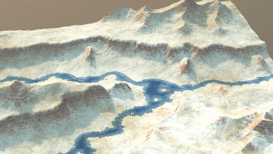
Authoring and Simulating Meandering Rivers
August 22, 2023
 Our work on meandering
rivers has been accepted at ACM Transactions on
Graphics, and will be presented at SIGGRAPH ASIA.
Our work on meandering
rivers has been accepted at ACM Transactions on
Graphics, and will be presented at SIGGRAPH ASIA.
We present a method for interactively authoring and simulating meandering river networks. Starting from a terrain with an initial low-resolution network encoded as a directed graph, we simulate the evolution of the path of the different river channels using a physically-based migration equation augmented with control terms. The curvature-based terms in the equation allow us to reproduce phenomena identified in geomorphology, such as downstream migration of bends. Control terms account for the influence of the landscape topography and user-defined river trajectory constraints. Our model implements abrupt events that shape meandering networks, such as cutoffs forming oxbow lakes and avulsions. We visually show the effectiveness of our method and compare the generated networks quantitatively to river data by analyzing sinuosity and wavelength metrics. Our vector-based model runs at interactive rates, allowing for efficient authoring of large-scale meandering networks.
-
Modeling and simulating scenic landscapes
June 22, 2023
I will present a talk on landscape Modeling and simulating scenic landscapes at Ecole Nationale Supérieur de Géologie de Nancy.
Modeling realistic and controllable large-scale landscapes is essential for creating virtual worlds. The challenge stems not only from the complexity of landforms, the variety of details and patterns at different scales, the need for geomorphological and hydrological realism, and the complexity of ecosystems but also from the need to control the shape and location of landforms to follow the designer's intent. In this talk, I will present some recent research that aims at bridging the gap between simulation providing realism and interactive editing giving control.
-
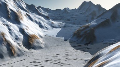
Forming Terrains by Glacial Erosion
April 24, 2023
Our work on glacial erosion has been accepted at ACM Transactions on Graphics, and will be presented at SIGGRAPH.
We introduce the first solution for simulating the formation and evolution of glaciers, together with their attendant erosive effects, for periods covering the combination of glacial and inter-glacial cycles. Our efficient solution includes both a fast yet accurate deep learning-based estimation of high-order ice flows and a new, multi-scale advection scheme enabling us to account for the distinct time scales at which glaciers reach equilibrium compared to eroding the terrain. We combine the resulting glacial erosion model with finer-scale erosive phenomena to account for the transport of debris flowing from cliffs. This enables us to model the formation of terrain shapes not previously adequately modeled in Computer Graphics, ranging from U-shaped and hanging valleys to fjords and glacial lakes.
-
Large-scale terrain authoring through interactive erosion simulation
March 14, 2023
 Our work on large-scale terrain
synthesis has been accepted at ACM Transactions on
Graphics, and will be presented at SIGGRAPH.
Our work on large-scale terrain
synthesis has been accepted at ACM Transactions on
Graphics, and will be presented at SIGGRAPH.
Large-scale terrains are essential in the definition of virtual worlds. Given the diversity of landforms and the geomorphological complexity, there is a need for authoring techniques offering hydrological consistency without sacrificing user control. In this paper, we bridge the gap between largescale erosion simulation and authoring into an efficient framework. We set aside modelling in the elevation domain in favour of the uplift domain, and compute emerging reliefs by simulating the stream power erosion. Our simulation relies on a fast yet accurate approximation of drainage area and flow routing to compute the erosion interactively, which allows for incremental authoring. Our model provides landscape artists with tools for shaping mountain ranges and valleys, such as copy-and-paste operations; warping for imitating folds and faults; point and curve elevation constraints to precisely sculpt ridges or carve river networks. It also lends itself to inverse procedural modelling by reconstructing the uplift from an input digital elevation model and allows hydrologically consistent blending between terrain patches.
-
Perceived Terrain Realism Metric
July 17, 2022
Our work on perceived errain realism metrics has been accepted at ACM Transactions on Applied Perception.
Terrains are visually prominent and commonly needed objects in many computer graphics applications. While there are many algorithms for synthetic terrain generation, it is rather difficult to assess the realism of a generated output. This article presents a first step toward the direction of perceptual evaluation for terrain models. We gathered and categorized several classes of real terrains, and we generated synthetic terrain models using computer graphics methods. The terrain geometries were rendered by using the same texturing, lighting, and camera position. Two studies on these image sets were conducted, ranking the terrains perceptually, and showing that the synthetic terrains are perceived as lacking realism compared to the real ones. We provide insight into the features that affect the perceived realism by a quantitative evaluation based on localized geomorphology-based landform features (geomorphons) that categorize terrain structures such as valleys, ridges, hollows, and so forth. We show that the presence or absence of certain features has a significant perceptual effect. The importance and presence of the terrain features were confirmed by using a generative deep neural network that transferred the features between the geometric models of the real terrains and the synthetic ones. The feature transfer was followed by another perceptual experiment that further showed their importance and effect on perceived realism. We then introduce Perceived Terrain Realism Metrics (PTRM), which estimates human-perceived realism of a terrain represented as a digital elevation map by relating the distribution of terrain features with their perceived realism. This metric can be used on a synthetic terrain, and it will output an estimated level of perceived realism. We validated the proposed metrics on real and synthetic data and compared them to the perceptual studies.
-
Gradient Terrain Authoring
January 11, 2022
 Our work on gradient terrain authoring has been accepted at Eurographics 2022.
We propose setting aside the elevation domain in favour of modelling in the gradient domain. Such a slope-based representation is height independent and allows a seamless blending of disparate landforms from procedural, simulation, and real-world sources. For output, an elevation model can always be recovered using Poisson reconstruction, which can include Dirichlet conditions to constrain the elevation of points and curves. In terms of authoring our approach has numerous benefits. It provides artists with a complete toolbox, including: cut-and-paste operations that support warping as needed to fit the destination terrain, brushes to modify region characteristics, and sketching to provide point and curve constraints on both elevation and gradient. It is also a unifying representation that enables the inclusion of tools from the spectrum of existing procedural and simulation methods, such as painting localised high-frequency noise or hydraulic erosion, without breaking the formalism.
-
AMPLI
September 1, 2021
The project AMPLI has been accepted by the French ANR. This project aims at defining learning processes for the inverse procedural modeling of virtual worlds.
-
Synthesizing Geologically Coherent Cave Networks
August 31, 2021
 Our work on modelling karstic networks has been accepted at Pacific Graphics 2021.
We present a geologically-based method to generate complex karstic networks. Karsts are a type of landscape formed by the dissolution of highly soluble rocks (generally limestones). In particular, they are characterized by complex underground networks made of varieties of tunnels and breakout chambers with stalagmites and stalactites. Our method computes skeletons of karstic networks by using a gridless anisotropic shortest path algorithm according to field data of the underground system (such as inlets and outlets), geomorphological features and parameters such as faults, inception horizons, fractures, and permeability contrasts. From this skeleton, we define the geometry of the conduits as a signed distance function construction tree combining primitives with blending and warping operators. Our framework provides multiple levels of control, allowing us to author both the structure of the karstic network and the geometric cross-section shapes and details of the generated conduits.
-
Modeling rock fractures
October 23, 2020
Our article on Modeling rock fractures has been awarded the best The Visual Computer award at CGI 2020.
-
Glacier simulation
August 31, 2020
 Our article on glaciers has been accepted at SIGGRAPH ASIA
2020.
Our article on glaciers has been accepted at SIGGRAPH ASIA
2020.
In this paper, we combine a Shallow Ice Approximation simulation with a procedural amplification process to author high-resolution realistic glaciers. Our multi-resolution method allows the interactive simulation of the formation and the evolution of glaciers over hundreds of years. The user can easily modify the environment variables, such as the average temperature or precipitation rate, to control the glacier growth, or directly use brushes to sculpt the ice or bedrock with interactive feedback. Mesoscale and small-scale landforms that are not captured by the glacier simulation, such as crevasses, moraines, seracs, ogives, or icefalls are synthesized using procedural rules inspired by observations in glaciology and according to the physical parameters derived from the simulation. Our method lends itself to seamless integration into production pipelines to decorate reliefs with glaciers and realistic ice features.
-
Ecosystems
August 31, 2020
 Our work ecosystem simulation has been accepted at SIGGRAPH ASIA 2020.
Ecosystem simulations embody many of the botanical influences, such as sunlight, temperature, and moisture, but require hours to complete, while synthesis from statistical distributions tends not to capture fine-scale variety and complexity. Instead, we leverage real-world data and machine learning to derive a canopy height model (CHM) for unseen terrain provided by the user. Trees in the canopy layer are then fitted to the resulting CHM through a constrained iterative process that optimizes for a given distribution of species, and, finally, an understorey layer is synthesised using distributions derived from biome-specific undergrowth simulations. Such a hybrid datadriven approach has the advantage that it incorporates subtle biotic, abiotic, and disturbance factors implicitly encoded in the source data and evidences accepted biological behaviour, such as self-thinning, climatic adaptation, and gap dynamics.
-
Texture Basis Functions
June 15, 2020
Our work Semi-Procedural Textures Using Point Process Texture Basis Functions has been accepted at Eurographics Symposium on Rendering 2020.
Honorable Mention from Best Paper Committee of EGSR.
We introduce a novel semi-procedural approach that avoids drawbacks of procedural textures and leverages advantages of data-driven texture synthesis. We split synthesis in two parts: structure synthesis, based on a procedural parametric model, and color details synthesis, being data-driven. The procedural model consists of a generic Point Process Texture Basis Function, which extends sparse convolution noises by defining rich convolution kernels. They consist of a window function multiplied with a statistical mixture of Gabor functions, both designed to encapsulate a large span of spatial stochastic structures, including cells, cracks, grains, scratches, spots, stains, and waves. Parameters can be prescribed automatically by supplying binary structure exemplars. As for noise-based Gaussian textures, our function is a stand-alone function, avoiding classification tasks that occur when handling multiple procedural assets. The generated procedural noises are parametric, infinite, continuous, and they avoid repetition. The synthesis of the data-driven part is automatic and guarantees strong visual resemblance with inputs.
-
Digital Elevation Model Repository
June 1, 2020
The Digital Elevation Model Database repository is now online.
Along with our STAR paper entitled A state-of-the-art review of digital terrain modeling comes a Digital Elevation Model respotitory that lists all the DEM we have been able to collect from research works, custom reimplementations, or our methods. We hope that this initiative will help the community by being able to compare their work to previous ones.
-
Modeling rock fractures
April 30, 2020
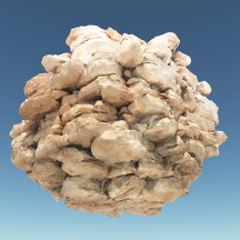 Modeling Rocky Scenery using Implicit Blocks has been accepted at Computer Graphics
International 2020.
Modeling Rocky Scenery using Implicit Blocks has been accepted at Computer Graphics
International 2020.
We present a novel geologically-based method to generate vertical walls of rocky cliffs, crags or promontories. Our method procedurally generates a distribution of fractures in the bedrock to create a set of tiling blocks defined as implicit volumetric primitives. Blocks are in turn implicitly replicated over the vertical parts of the terrain and combined together to obtain a consistent volumetric representation of the fractured bedrock patterns using generalized union and blending operators. Our framework provides multiple levels of control: in addition to automatically generated blocks, the geometry of specific ones can be prescribed by the user using implicit primitives or construction trees, the shape of the blocks can be controlled by several parameters, and the placement rules may adapt according to the underlying geological strata and geometry of the terrain.
-
Procedural planets
April 30, 2020
Our work Real-Time Hyper-Amplification of Planets has been accepted at Computer Graphics International 2020.
We propose an original method for generating planets with a high level of detail in real-time. Our approach relies on a procedural hyper-amplification algorithm: a controlled subdivision process that faithfully reproduces landforms and hydrosphere features at different scales. Starting from low-resolution user-defined control maps that provide information about the elevation, presence of large-scale water bodies and landforms types, we apply subdivision rules to obtain a high resolution hydrologically consistent planet model. We first generate a large-scale river networks connected to inner seas and oceans, then synthesize the detailed hydrographic landscapes, including river tributaries and lakes, %landforms including mountain ranges, valleys, plateaus, deserts and hills systems. Our GPU implementation allows to interactively explore planets that are produced by tectonic simulations, generated procedurally or authored by artists.
-
Ray Tracing Implicit Surfaces
February 13, 2020
Our work Segment Tracing Using Local Lipschitz Bounds has been accepted at Eurographic 2020.
We introduce Segment Tracing, a new algorithm that accelerates the classical Sphere Tracing method for computing the intersection between a ray and an implicit surface. Our approach consists in computing the Lipschitz bound locally over a segment to improve the marching step computation and accelerate the overall process. We describe the computation of the Lipschitz bound for different operators and primitives. We demonstrate that our algorithm significantly reduces the number of field function queries compared to previous methods, without the need for additional accelerating data-structures. Our method can be applied to a vast variety of implicit models ranging from hierarchical procedural objects built from complex primitives, to simulation-generated implicit surfaces created from many particles.
-
Invited speaker at Maison des Mathématiques et de l'Informatique
January 16, 2020
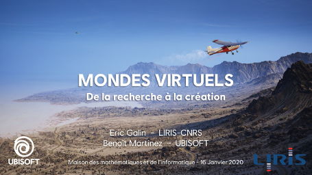 I will make a presentation entitled: Virtual Worlds: from Research to Creation.
Qu'ils servent de cadre à des effets spéciaux pour le cinéma, à entraîner des véhicules autonomes, ou des terrains d'aventure pour des jeux vidéo, les mondes virtuels représentent un véritable défi pour les créateurs. Cette quête de réalisme et d'interactivité se nourrit des dernières innovations de la recherche et derrière chaque montagne, rivière, arbre ou brin d'herbe se cachent des modèles mathématiques et des algorithmes. A travers des exemples concrets illustrant la création de terrains, de villages, de forêts ou encore de nuages, nous présenterons comment la recherche et la mise production, tout comme les arts et les sciences, peuvent s'alimenter l'un et l'autre.